 FROM HERE TO THERE: RAIL TRANSPORTATION AND GROWTH
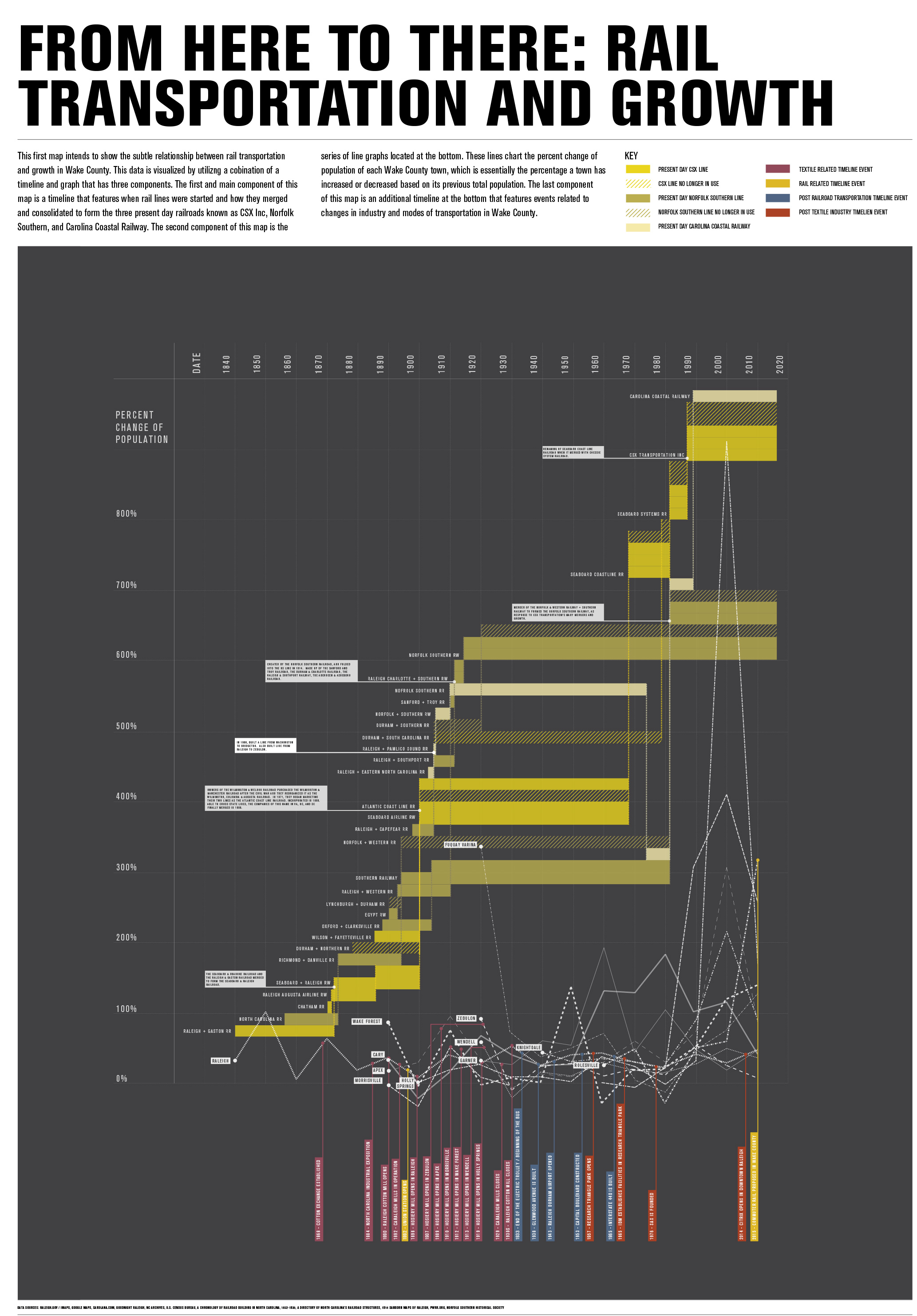
This first map intends to show the subtle relationship between rail transportation and growth in Wake County. This data is visualized by utilizing a combination of a timeline and graph that has three components. The first and main component of this map is a timeline that features when rail lines were started and how they merged and consolidated to form three present day railroads known as CSX Inc, Norfolk Southern, and Carolina Coastal Railway. The second component of this map is the series of line graphs located at the bottom. These lines chart the percent change of population of each Wake County town, which is essentially the percentage a town has increased or decreased based on its previous total population. The last component of this map is an additional timeline at the bottom that features events related to changes in industry and modes of transportation in Wake County.
FROM HERE TO THERE: RAIL TRANSPORTATION AND GROWTH
This first map intends to show the subtle relationship between rail transportation and growth in Wake County. This data is visualized by utilizing a combination of a timeline and graph that has three components. The first and main component of this map is a timeline that features when rail lines were started and how they merged and consolidated to form three present day railroads known as CSX Inc, Norfolk Southern, and Carolina Coastal Railway. The second component of this map is the series of line graphs located at the bottom. These lines chart the percent change of population of each Wake County town, which is essentially the percentage a town has increased or decreased based on its previous total population. The last component of this map is an additional timeline at the bottom that features events related to changes in industry and modes of transportation in Wake County.
 CASE STUDY: THE RALEIGH + GASTON RAILROAD
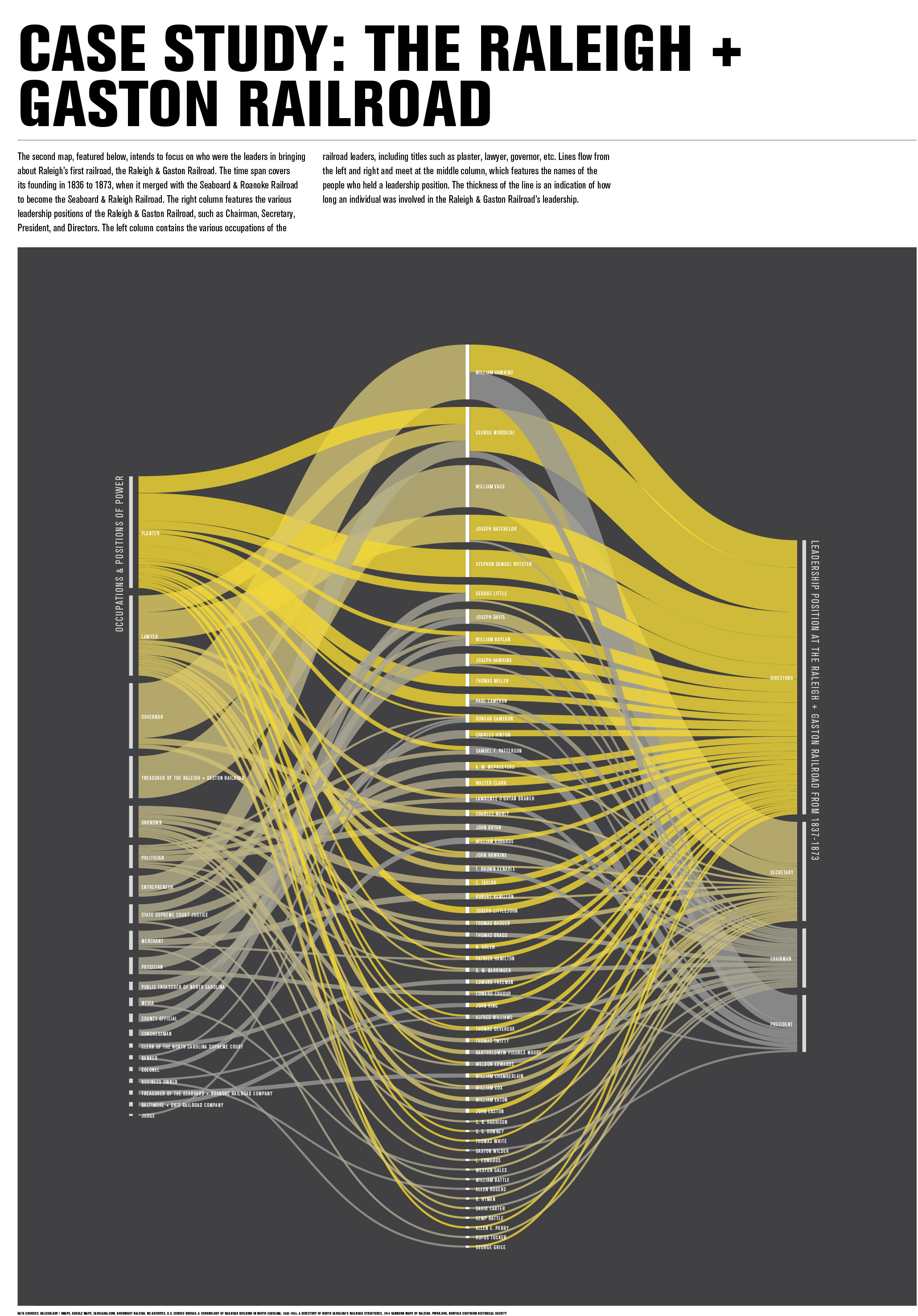
The second map intends to focus on who were the leaders in bringing about Raleigh’s first railroad, the Raleigh & Gaston Railroad. The time span covers its founding in 1836 to 1873, when it merged with the Seaboard & Roanoke Railroad to become the Seaboard & Raleigh Railroad. The right column features the various leadership positions of the Raleigh & Gaston Railroad, such as Chairman, Secretary, President, and Directors. The left column contains the various occupations of the railroad leaders, including titles such as planter, lawyer, governor, etc. Lines flow from the left and right and meet at the middle column, which features the names of the people who held a leadership position. The thickness of the line is an indication of how long an individual was involved in the Raleigh & Gaston Railroad’s leadership.
CASE STUDY: THE RALEIGH + GASTON RAILROAD
The second map intends to focus on who were the leaders in bringing about Raleigh’s first railroad, the Raleigh & Gaston Railroad. The time span covers its founding in 1836 to 1873, when it merged with the Seaboard & Roanoke Railroad to become the Seaboard & Raleigh Railroad. The right column features the various leadership positions of the Raleigh & Gaston Railroad, such as Chairman, Secretary, President, and Directors. The left column contains the various occupations of the railroad leaders, including titles such as planter, lawyer, governor, etc. Lines flow from the left and right and meet at the middle column, which features the names of the people who held a leadership position. The thickness of the line is an indication of how long an individual was involved in the Raleigh & Gaston Railroad’s leadership.