Transportation, Railways and Urban Development
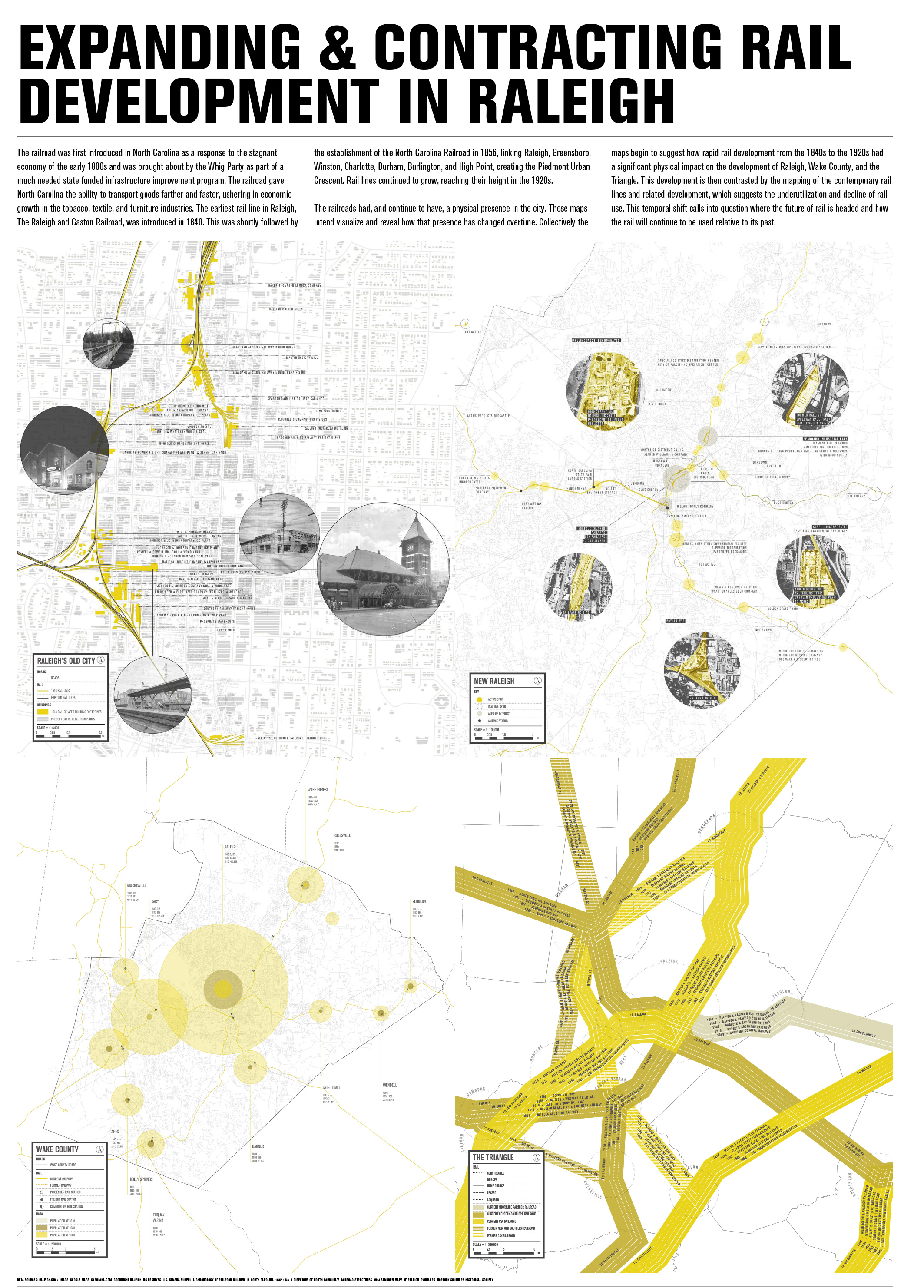
EXPANDING & CONTRACTING RAIL DEVELOPMENT IN RALEIGH
The railroad was first introduced in North Carolina as a response to the stagnant economy of the early 1800s and was brought about by the Whig Party as part of a much needed state funded infrastructure improvement program. The railroad gave North Carolina the ability to transport goods farther and faster, ushering in economic growth in the tobacco, textile, and furniture industries. The earliest rail line in Raleigh, The Raleigh and Gaston Railroad, was introduced in 1840. This was shortly followed by the establishment of the North Carolina Railroad in 1856, linking Raleigh, Greensboro, Winston, Charlotte, Durham, Burlington, and High Point, creating the Piedmont Urban Crescent. Rail lines continued to grow, reaching their height in the 1920s.
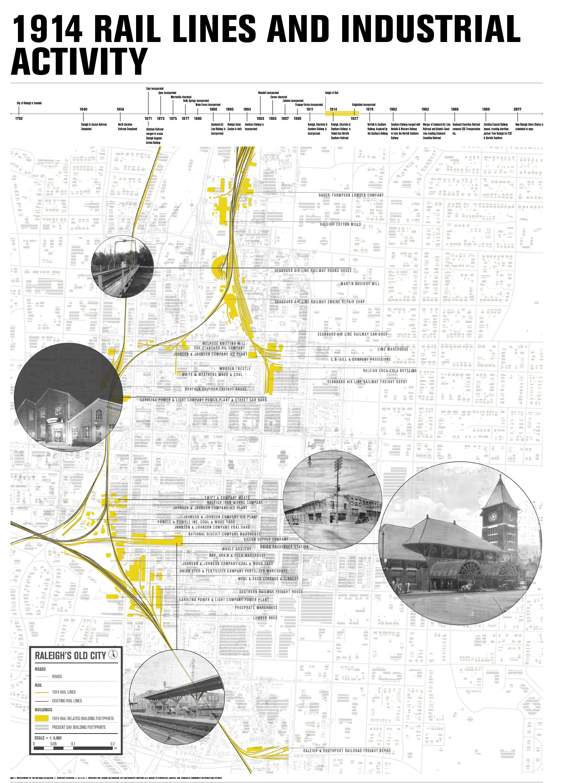
1914 RAIL LINES AND INDUSTRIAL ACTIVITY
The railroads had, and continue to have, a physical presence in the city. These maps intend visualize and reveal how that presence has changed overtime. Collectively the maps begin to suggest how rapid rail development from the 1840s to the 1920s had a significant physical impact on the development of Raleigh, Wake County, and the Triangle. This development is then contrasted by the mapping of the contemporary rail lines and related development, which suggests the underutilization and decline of rail use. This temporal shift calls into question where the future of rail is headed and how the rail will continue to be used relative to its past.
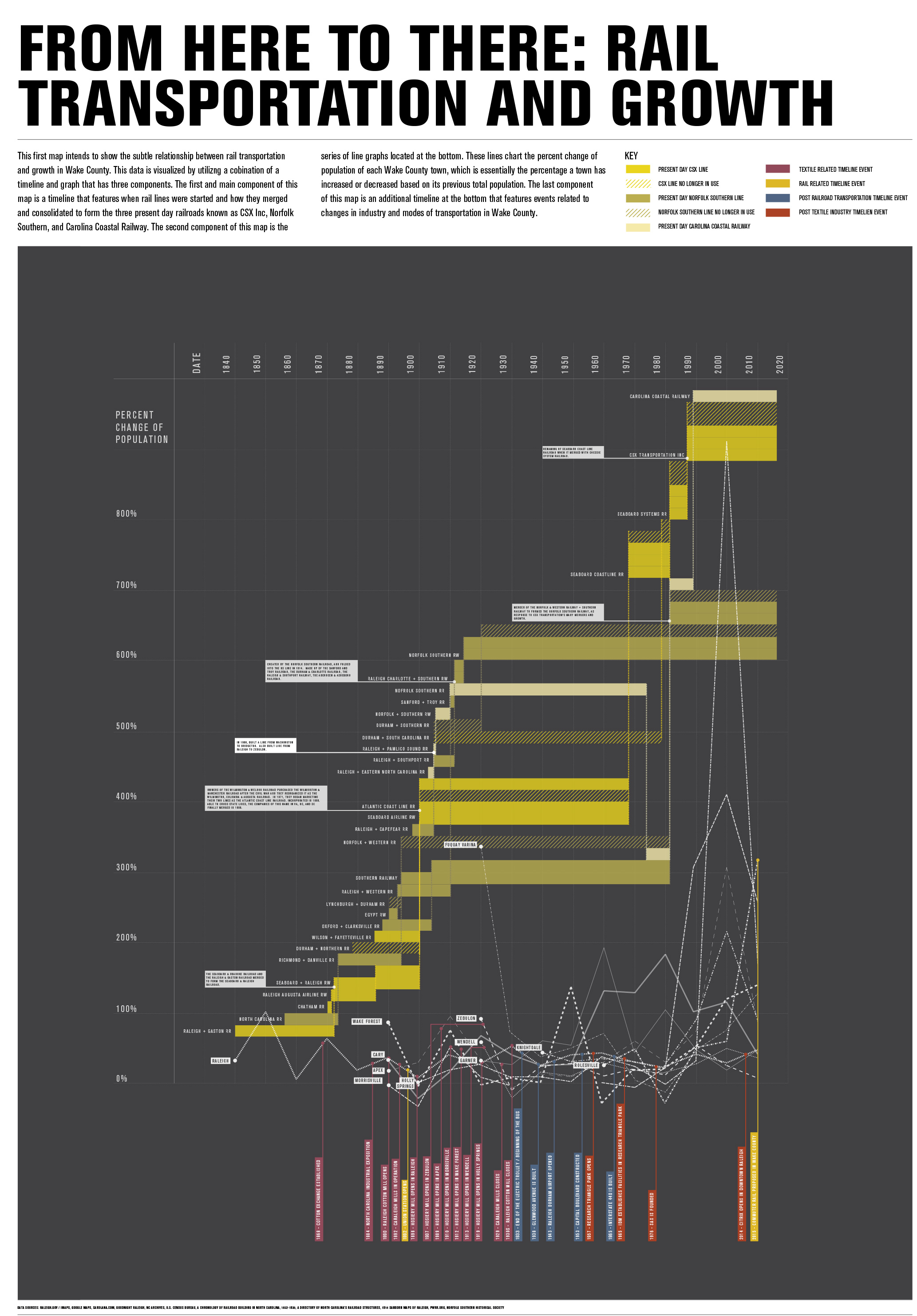
FROM HERE TO THERE: RAIL TRANSPORTATION AND GROWTH
This first map intends to show the subtle relationship between rail transportation and growth in Wake County. This data is visualized by utilizing a combination of a timeline and graph that has three components. The first and main component of this map is a timeline that features when rail lines were started and how they merged and consolidated to form three present day railroads known as CSX Inc, Norfolk Southern, and Carolina Coastal Railway. The second component of this map is the series of line graphs located at the bottom. These lines chart the percent change of population of each Wake County town, which is essentially the percentage a town has increased or decreased based on its previous total population. The last component of this map is an additional timeline at the bottom that features events related to changes in industry and modes of transportation in Wake County.
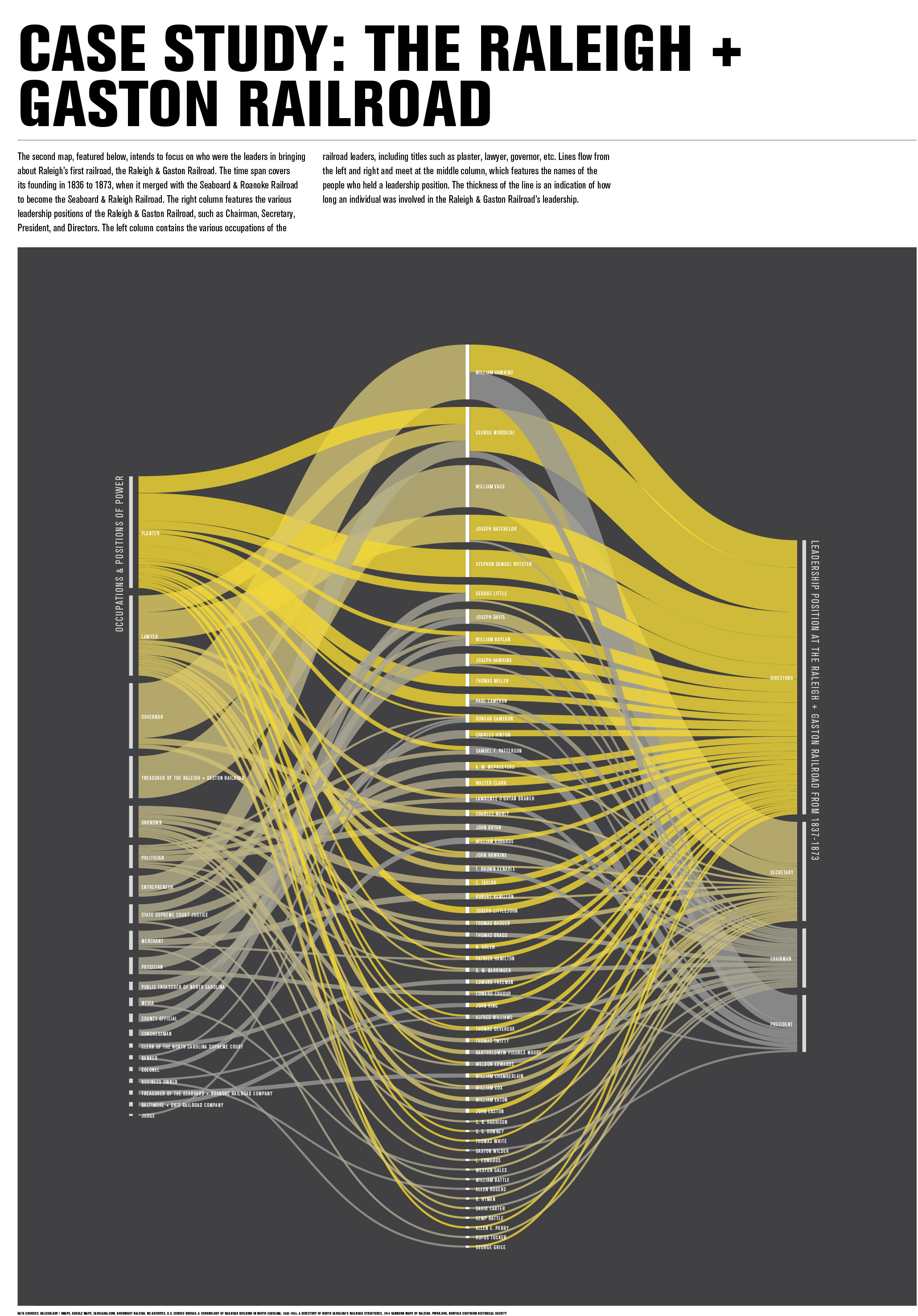
CASE STUDY: THE RALEIGH + GASTON RAILROAD
The second map intends to focus on who were the leaders in bringing about Raleigh’s first railroad, the Raleigh & Gaston Railroad. The time span covers its founding in 1836 to 1873, when it merged with the Seaboard & Roanoke Railroad to become the Seaboard & Raleigh Railroad. The right column features the various leadership positions of the Raleigh & Gaston Railroad, such as Chairman, Secretary, President, and Directors. The left column contains the various occupations of the railroad leaders, including titles such as planter, lawyer, governor, etc. Lines flow from the left and right and meet at the middle column, which features the names of the people who held a leadership position. The thickness of the line is an indication of how long an individual was involved in the Raleigh & Gaston Railroad’s leadership.
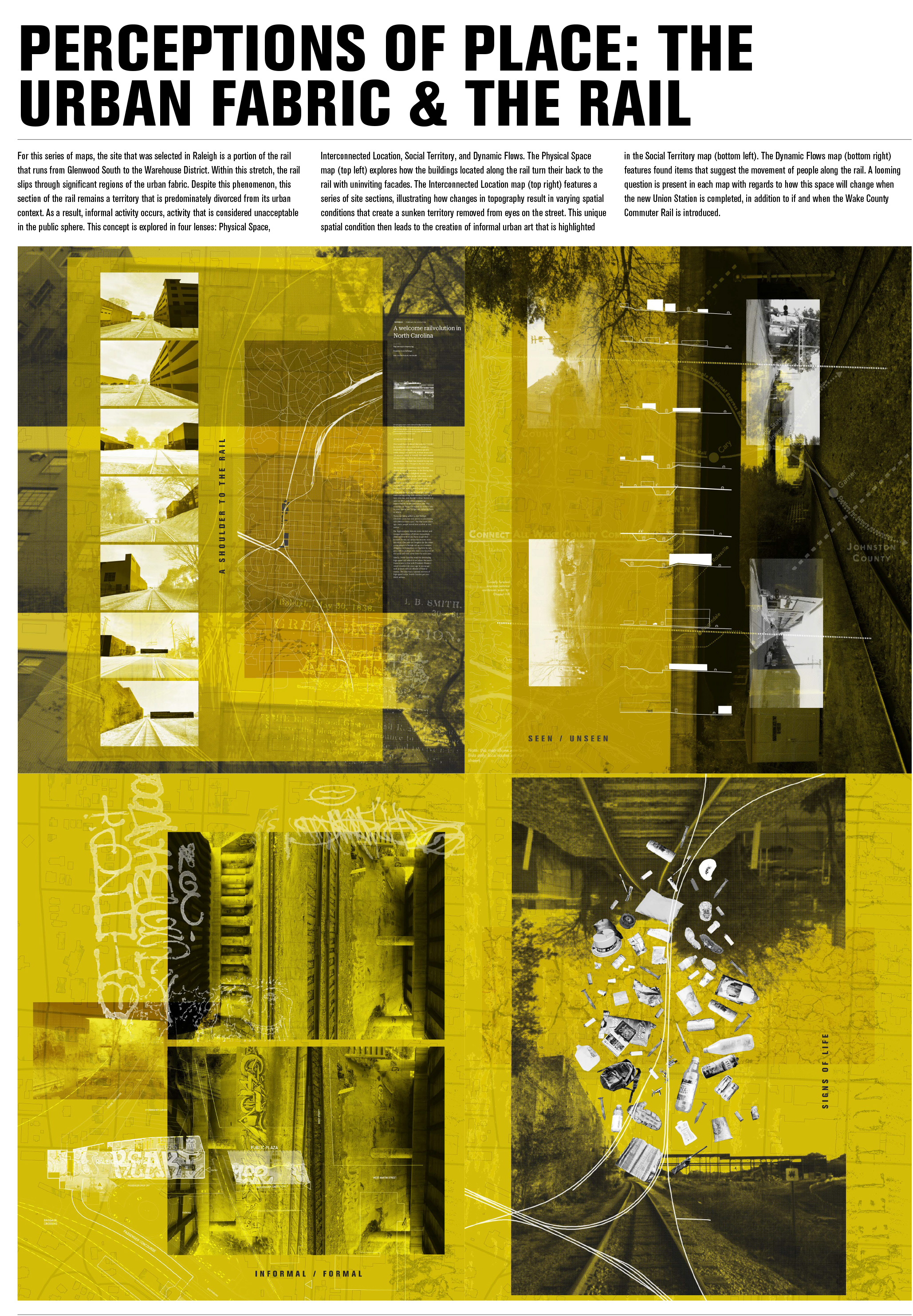
PERCEPTIONS OF PLACE: THE URBAN FABRIC & THE RAIL
For this series of maps, the selected Raleigh location is a portion of the rail that runs from Glenwood South to the Warehouse District. Within this stretch, the rail slips through significant regions of the urban fabric. Despite this phenomenon, this section of the rail remains a territory that is predominately divorced from its urban context. As a result, informal activity occurs, activity that is considered unacceptable in the public sphere. This concept is explored in four lenses: Physical Space, Interconnected Location, Social Territory, and Dynamic Flows.
The Physical Space map (top left) explores how the buildings located along the rail turn their back to the rail with uninviting facades. The Interconnected Location map (top right) features a series of site sections, illustrating how changes in topography result in varying spatial conditions that create a sunken territory removed from eyes on the street. This unique spatial condition then leads to the creation of informal urban art that is highlighted in the Social Territory map (bottom left). The Dynamic Flows map (bottom right) features found items that suggest the movement of people along the rail. A looming question is present in each map with regards to how this space will change when the new Union Station is completed – if and when the Wake County Commuter Rail is introduced.
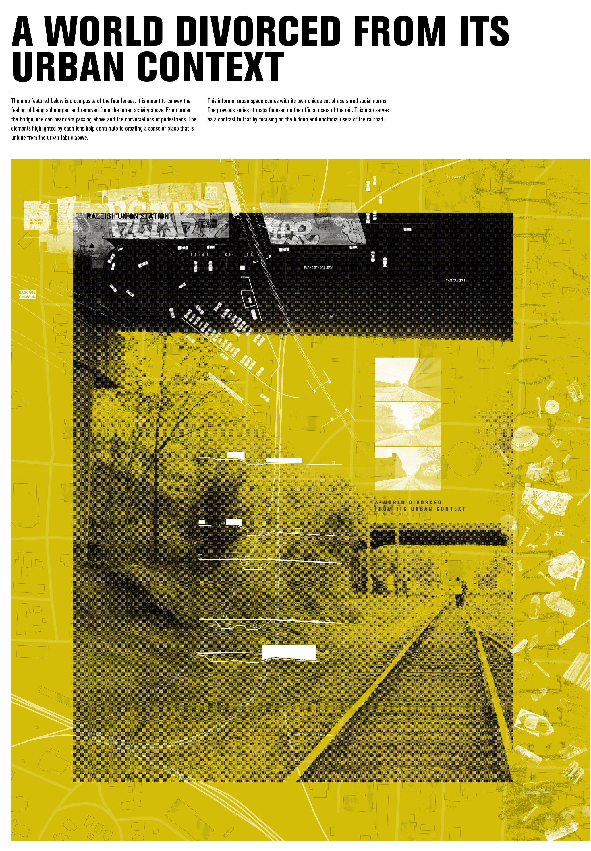
A WORLD DIVORCED FROM ITS URBAN CONTEXT
This map is a composite of the four lenses. It is meant to convey the feeling of being submerged and removed from the urban activity above. From under the bridge, one can hear cars passing above and the conversations of pedestrians. The elements highlighted by each lens help contribute to creating a sense of place that is unique from the urban fabric shown in the quad series of maps.